Metromake / Features
Metromake 1.0.0

Road network editor features

Metromake 1.0.0 is a native desktop editor (C++, OpenGL) for building road networks lane by lane, with terrain and water, and exporting them to driving simulators and 3D engines.

01 — Roads

Roads and cross-sections

Spline roads with any cross-section. Everything on the road is generated from it and rebuilt live while you drag.

  • 10 lane types: driving, parking, bus, bike, shoulder, hatched, median, sidewalk, verge, barrier
  • Per-lane width, direction and height; 11 marking styles
  • Curbs, markings, crosswalks, bridges and street lights generated from the cross-section
  • Drag lane boundaries in the cross-section preview; save custom profiles
curbcurbsidewalkvergeparkingdrivingdrivingbikesidewalkcross-section: lane types, widths and markings, left to rightsectionplan
Diagram Cross-section in plan and section.
02 — Junctions

Junctions and roundabouts

Automatic junction surfaces for any number of roads.

  • 6 controls: priority, traffic signals, all-way stop, give way, uncontrolled, roundabout
  • Roundabouts size themselves to their roads, with flared entries, an island and a truck apron
  • Corner radius, crosswalks, stop lines and turn arrows per junction
reference lineroad (approach)junctionconnecting roads,one per movementlane links: within 2 cm,continuous heading
Diagram Connecting roads in the OpenDRIVE export.
03 — Signs

Signs with OpenDRIVE codes

27 sign types after the German StVO / Vienna Convention designs, including speed limits 10–130 km/h and their ends, and traffic lights. Each carries its OpenDRIVE code.

  • Placed beside a road, facing the traffic on that side
  • Stay attached when roads are split, joined or reversed
  • Exported to OpenDRIVE as signals, and to glTF/OBJ with their texture
Sign catalogue sheet drawn by Metromake: stop, give way, priority, prohibition, instruction, information and warning signs, traffic light, and speed limits 10 to 130 km/h with their end signs.
Fig. The sign catalogue, drawn by Metromake itself.

Catalogue and OpenDRIVE codes

Stop206
Give way205
Priority road306
End of priority road307
Priority at next junction301
Speed limit (10–130 km/h)274
End of speed limit278
No entry267
No vehicles250
No overtaking276
No stopping283
No parking286
Ahead only209-30
Turn left209-10
Turn right209-20
Keep right222
Roundabout215
One way220-20
Pedestrian crossing350-10
Parking314
Danger101
Pedestrians133-10
Children136-10
Cyclists138-10
Road works123
Traffic signals ahead131
Traffic light1000001
04 — Terrain and water

Terrain and water

Sculpt the ground and add water; roads keep their shape when the ground moves.
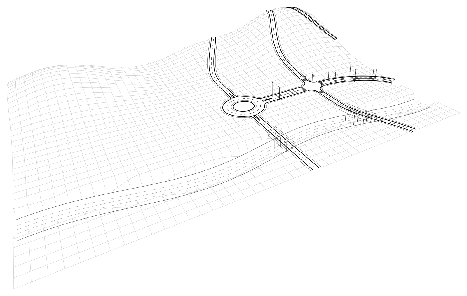
  • Sculpt with brush, area and road-corridor tools
  • Water: basin fill, brush, ponds and rivers that flow downhill
  • 8 map templates: flat, water, plains, hills, mountains, islands, lakes, river valley
  • Lower the ground under a road and it becomes a bridge with piers
Wireframe 3D view of roads draped over hills, with bridges across a river valley.
Fig. Roads follow the terrain; the bridges span the river valley.
05 — Views

2D blueprint view and 3D view

Switch between a 3D view and a 2D blueprint view with contour lines and a height cut.
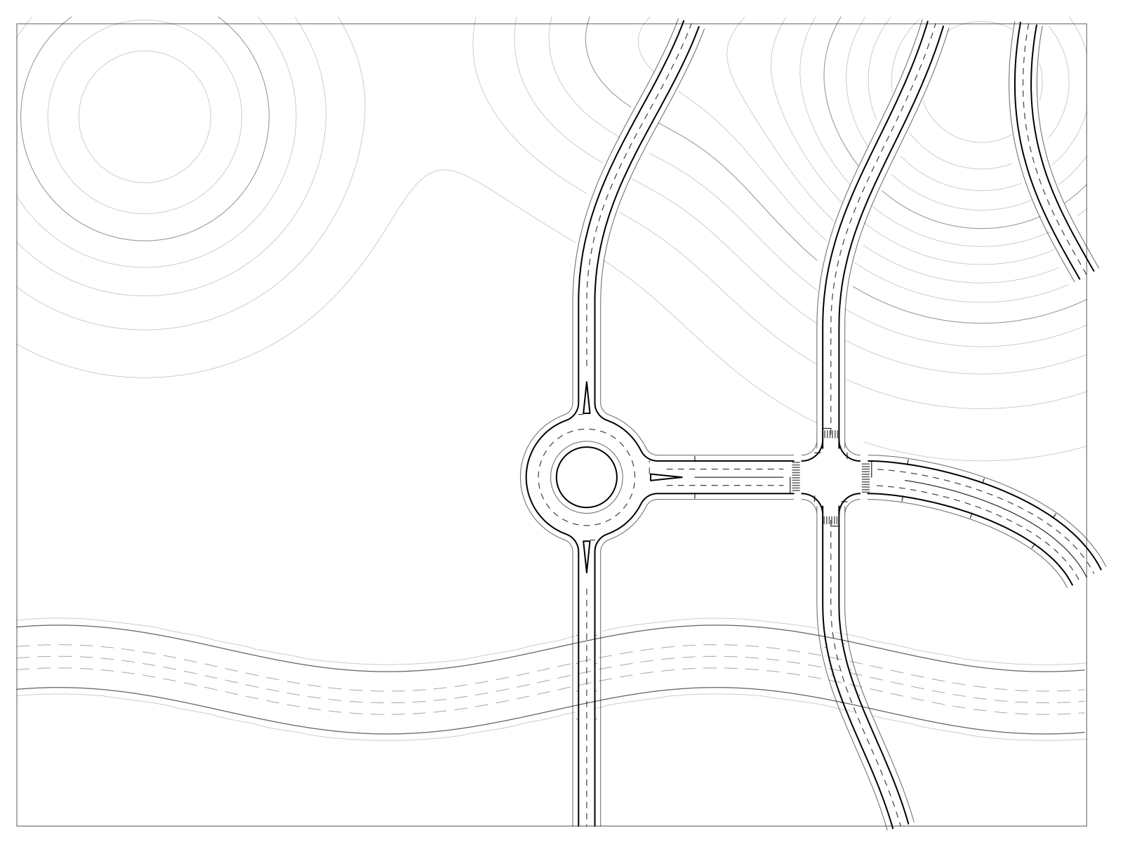
  • Height cut: hide everything above a level, for example to see under a bridge
  • All editing tools work in 2D too
  • Light and dark themes
Plan view of a road network with terrain contour lines: a signalised crossroads, a roundabout, a river and two bridges, with open ground to the west.
Fig. Plan view with contour lines.
06 — Projects

Projects of several maps

Place maps side by side on a shared plane; roads continue across map edges.
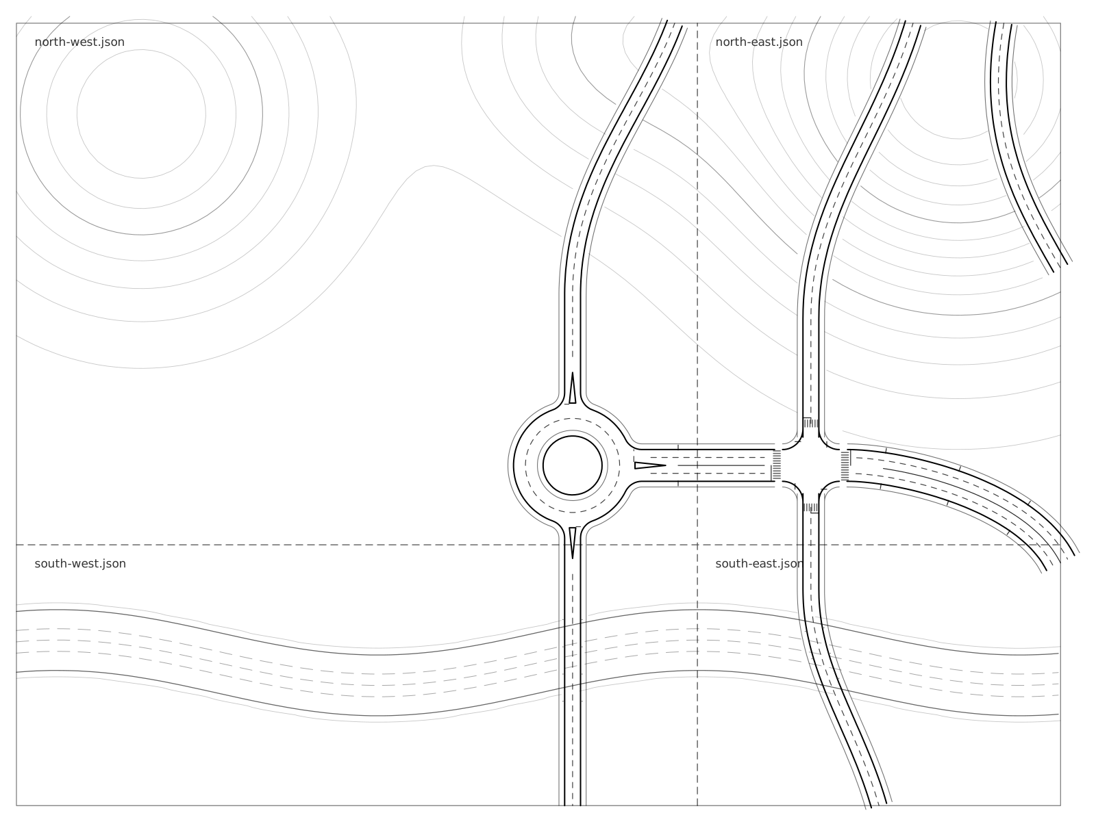
  • Drag maps into place; edges snap to neighbours
  • Binding points join roads across map edges, with matching lane profiles
  • Terrain blends along shared edges
Plan view of one road network split across four maps of a project, with roads crossing the map edges.
Fig. Four maps of one project; roads continue across map edges.
07 — Import and export

Import and export formats

ineditoutOpenStreetMap.osmOpenDRIVE.xodrHeightmap.png / .r16Metromake maplanes, junctions,signs, terrain, waterplain JSONOpenDRIVE 1.6.xodrOpenSCENARIO 1.2.xoscglTF 2.0.glb/.gltfOBJ.objHeightmap.png/.r16
Diagram Formats in and out.
Simulation export

OpenDRIVE 1.6, OpenSCENARIO 1.2

Lanes, lane links, junctions with lane-level connecting roads, roundabouts, elevation, signals, georeference. 3 scenario templates. Details

3D export

glTF 2.0, OBJ, heightmap

.glb / .gltf, .obj, 16-bit heightmap (PNG + RAW .r16). Details

Import

OpenStreetMap, OpenDRIVE, heightmaps

.osm, .xodr and 16/8-bit PNG or .r16 heightmaps. Details

08 — Workflow

Workflow and privacy

Start menu

Blueprint previews of your maps and projects.

Safe by default

Autosave, crash recovery and undo.

Plain JSON

Map files you can read, diff and generate.

Offline

No account, no telemetry, no network access. Command-line export for pipelines.

Next step

See it on your own roads.

Join the waiting list to hear when downloads open.